An Arduous Journey
After burying their colleague, Alexander Kellas, the expedition continued further into Tibet,
all the time moving closer to their goal, Mount Everest. The challenges of the landscape threatened to
hamper the team's progress but they found many moments to revel in the splendour of their surroundings.
all the time moving closer to their goal, Mount Everest. The challenges of the landscape threatened to
hamper the team's progress but they found many moments to revel in the splendour of their surroundings.
Frank Nugent describes the team's journey into Tibet.
The film contains photos supplied by Westmeath Library Services and the Alpine Club Photo Library, London.
The film contains photos supplied by Westmeath Library Services and the Alpine Club Photo Library, London.
The marker shows the location of Mount Everest
The 1921 reconnaissance team approached the mountain from Tibet, after travelling from Sikkim in India
Zoom in to see more detail
The Road to Everest: June 1921
|
After Kampa Dzong, the team travelled west to the the nearby Tinki Dzong. Howard-Bury described the scene: 'The midges or sand flies were very troublesome the whole way and came in hundreds round one's head, got inside one's topee, and were thoroughly objectionable. The plain appeared very fertile, as there seemed to be plenty of water and great herds of yaks and flocks of sheep were grazing upon it. In the marshes and ponds were many bar-headed geese, Brahminy ducks, mallard and teal. After the rains, it is evident that a great part of this plain is under water. About a couple of miles from Tinki we crossed some curious sand dunes, about 20 feet high, which are evidently on the move, and soon afterwards the Jongpen [governor - both Dzongpen and Jongpen are used in the official narrative] of Tinki came riding out to meet us with a few mounted followers, he himself riding a fine white pony. He was very Chinese in appearance, wearing finely embroidered silks with a Chinese hat and a long pigtail, and his manners were excellent. He escorted us to the place where our camp was to be, and had had three or four tents already pitched for us. Tea and country beer were at once served, and we rested in the shade of his Chinese tents until our transport arrived.'
From Tinki Dzong, the expedition trekked towards Shekar Dzong, passing 'well-irrigated fields of barley'. They soon reached a river called the Bhong-chu which was 'nearly 200 yards in width, but there was quite a good ford across it'. This region was contained 'many flourishing villages and much cultivation'. From one hill, Howard-Bury could see fifteen villages. Although the weather was uncomfortably hot, the countryside was beautiful: 'I went up a side valley which turned out to be extremely pretty. It was very narrow and a mass of wild rose bushes. These roses were all of a creamy yellow, and every bush was covered with hundreds of sweet-smelling flowers. There was also a curious black clematis and several species of broom and rock cistus. Here and there were grassy patches with bubbling springs of crystal clearness. Rock pigeons, Brahminy ducks, blackbirds and numerous other varieties of small birds came down to drink here and did not mind us at all.' |
Charles Howard-Bury describes his stay at Tinki Dzong in this segment from Mount Everest - the Reconnaissance. The reading is by actor John McGlynn.
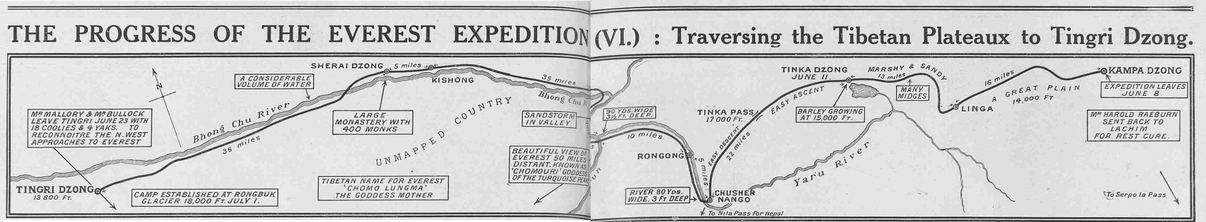
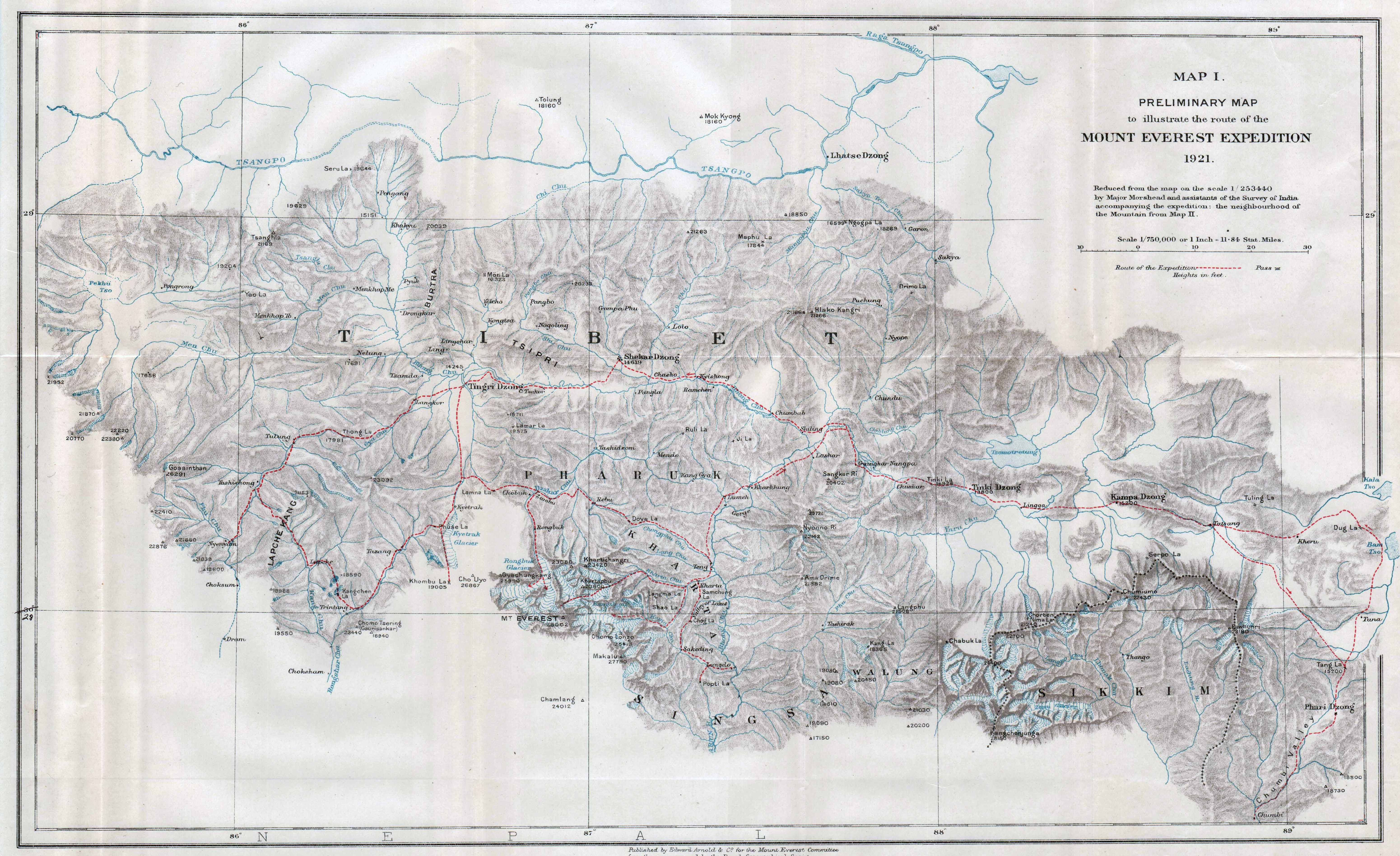
A map that appeared in the Sphere, 27 August 1921. It shows the route from Khamba Dzong to Tingri Dzong.
From Tingri, the team would move south to Everest.
From Tingri, the team would move south to Everest.
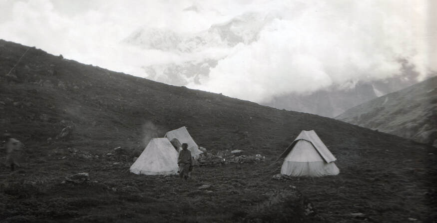
The expedition carried whymper and mummery tents, which were standard gear for mountaineers at the time.
(Marian Keaney/Westmeath Library Services: Howard-Bury Collection)
(Marian Keaney/Westmeath Library Services: Howard-Bury Collection)
|
Establishing a Base: June, July 1921
The expedition rested at Shekar Dzong on 17 June, near to the big monastery of Shekar Chö-te, which Howard-Bury visited and whose abbot he photographed (the photo is on the next page). The reconnaissance team was now very near to Mount Everest and the entire southern horizon was filled with mountains, as described by Howard-Bury: 'As we approached Tingri, the valley widened out and bent round to the South. Tingri itself was situated on the side of a small hill in the middle of a great plain, from which, looking to the South, was visible the wonderful chain of snowy peaks, many of them over 25,000 feet in height, which extends Westwards from Mount Everest. We crossed the Ra-chu, a tributary of the Bhong-chu, partly by bridges and partly by fords; it was split up into a number of small and very muddy channels that took their rise from the Kyetrak Glacier. Tingri was to be our first base for reconnoitering the Northern and North-western approaches to Mount Everest. It was June 19 when we arrived there, so that it had taken us just a month's travelling from Darjeeling to perform this part of our journey.'
From Tingri, Howard-Bury sent different parties to explore and map the valleys and passes to the North of Everest. Mallory and Bullock, along with Sherpas, were tasked with assessing possible routes along the mountain's north and north-west slopes; while Wheeler and Heron moved east to Kyetrak, where Wheeler began the photographic survey. Howard-Bury, along with his Tibetan cook, Poo, travelled to the Khumbu La, which leads to the Khumbu Valley in Nepal. The success or failure of the mission would be determined over the following two months. |
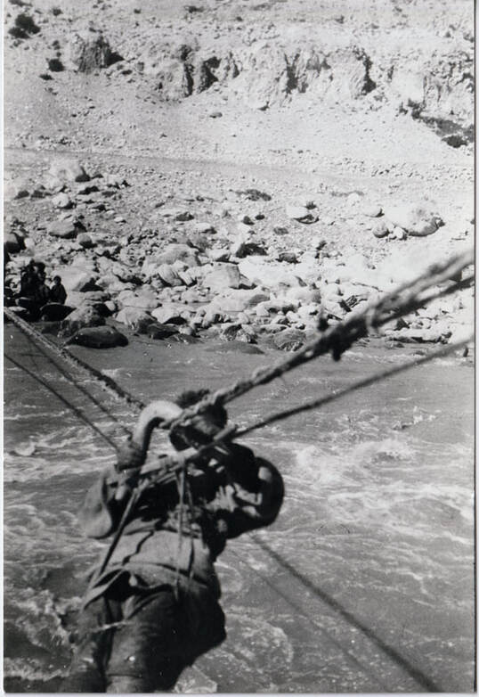
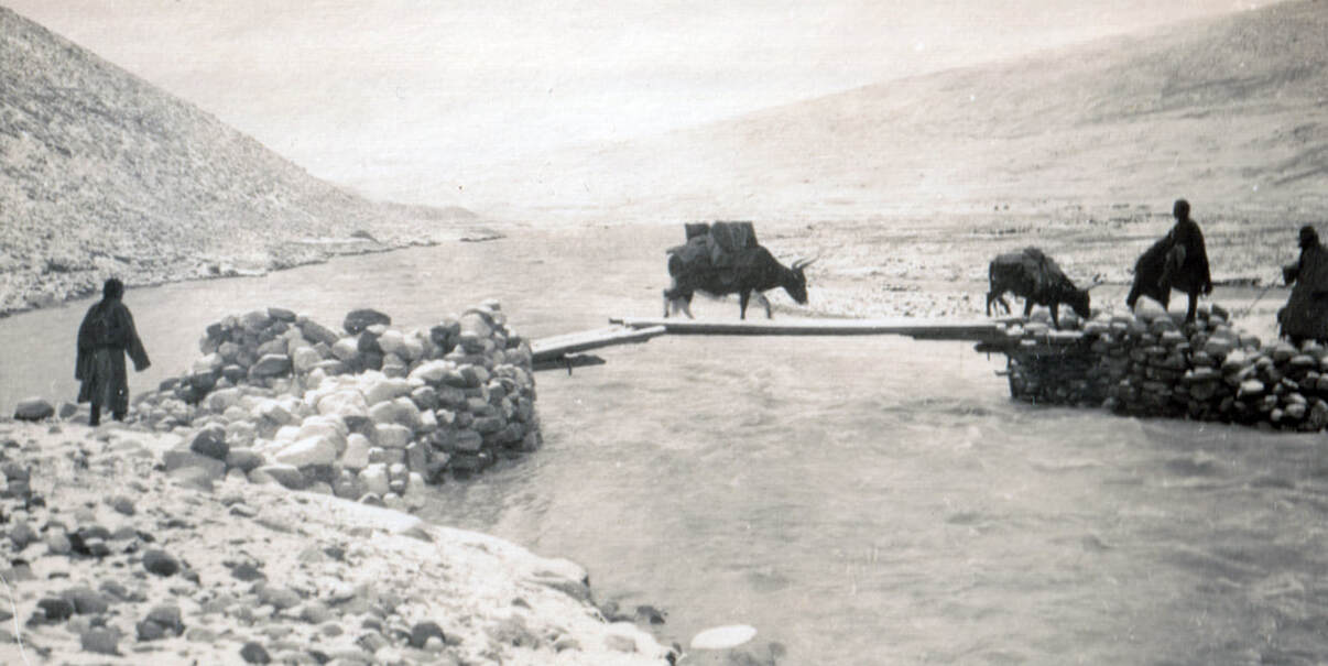
No bridge, no problem. A member of the expedition crosses a river using what appears to be a rope zip-line. The many mountain rivers often posed an impediment to progress. Howard-Bury described one occasion: 'I came to an unfordable stream, and after making several attempts to get across this, found myself compelled to return several miles down the valley to the monastery of Chöbu, where there was a slender footbridge. The pony that I was riding was swum across, a rope being attached to its head. He was then pulled over to the far side, a proceeding he did not at all enjoy. The yaks, too, were unladen, and the loads carried by hand over the bridge. After this the yaks were driven into the river and made to swim across, but they only went as far as an island in the middle of the river. From this place they would not budge in spite of stones, curses and threats, until at length a man with a sling, fetched from the monastery, hurled stones at them with great violence: this procedure apparently so stung them up that they thought it advisable to cross the remainder of the stream.' (Marian Keaney/Westmeath Library Services: Howard-Bury Collection)
|
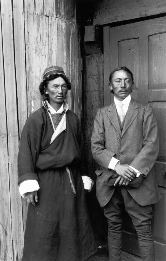
Interpreters Gyalzen Kazi (left) and Chhetan Wangdi (right). Howard-Bury considered them vital to the mission: 'It was essential to find men of some position and standing who knew not only the Tibetan language, but also all their ways and customs. After many names had been suggested, we were very lucky in getting hold of two men who possessed these qualifications to a great extent. Gyalzen Kazi, who came from Gangtok in Sikkim, where he was a Kazi and landowner, was a young and ambitious man who knew the Tibetan language well and was well read in their sacred writings and scriptures. The other one, Chheten [Chittan in some sources] Wangdi, was a Tibetan who had been for a time a captain in the Tibetan army, and who had left them and been attached to the Indian army in Egypt during the war.' Image reproduced with permission of the Royal Geographical Society (with IBG)’
|
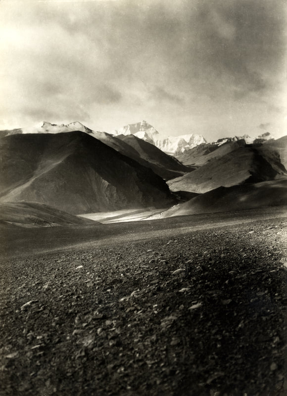
Mount Everest from a distance of about thirty-five kilometres: '... a prodigious white fang excrescent from the jaw of the world', as described by George Mallory. The photo was taken at an altitude of about 5,500 metres, looking south up the Rongbuk Valley. (Alpine Club Photo Library, London)
George Mallory considers Everest 'as a structure' in this segment from Mount Everest - the Reconnaissance. The reading is by actor John McGlynn.
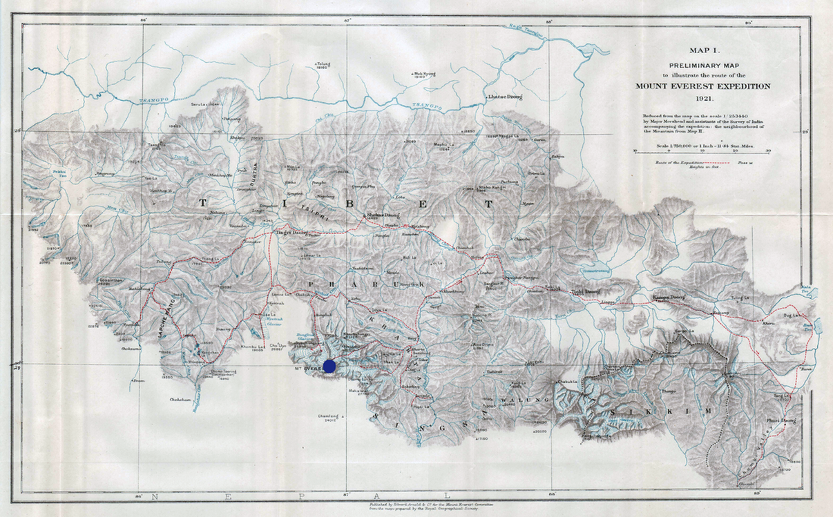
A map compiled by the expedition team, showing their route across southern Tibet and towards Mount Everest, which is marked by the blue circle
|
You can download an unmarked copy of
the above map here |
| ||
The reconnaissance team used yaks as pack animals (Marian Keaney/Westmeath Library Services: Howard-Bury Collection)
